Citizen scientists needed
Canopy cover is the area of land covered by tree branches and leaves. (Photo: Kate Sparrow, Forest Research)
Kate Sparrow and Kieron Doick, Forest Research
Canopy cover is fast becoming a widely adopted metric for understanding the extent of tree coverage across our towns and cities. Defined as the area of ground directly covered by the leaves and branches of trees, canopy cover is generally expressed simply, as a percentage. The simplicity of the metric means that it is easy to understand, which can be particularly beneficial when working with non-tree specialists to promote the benefits of urban trees.
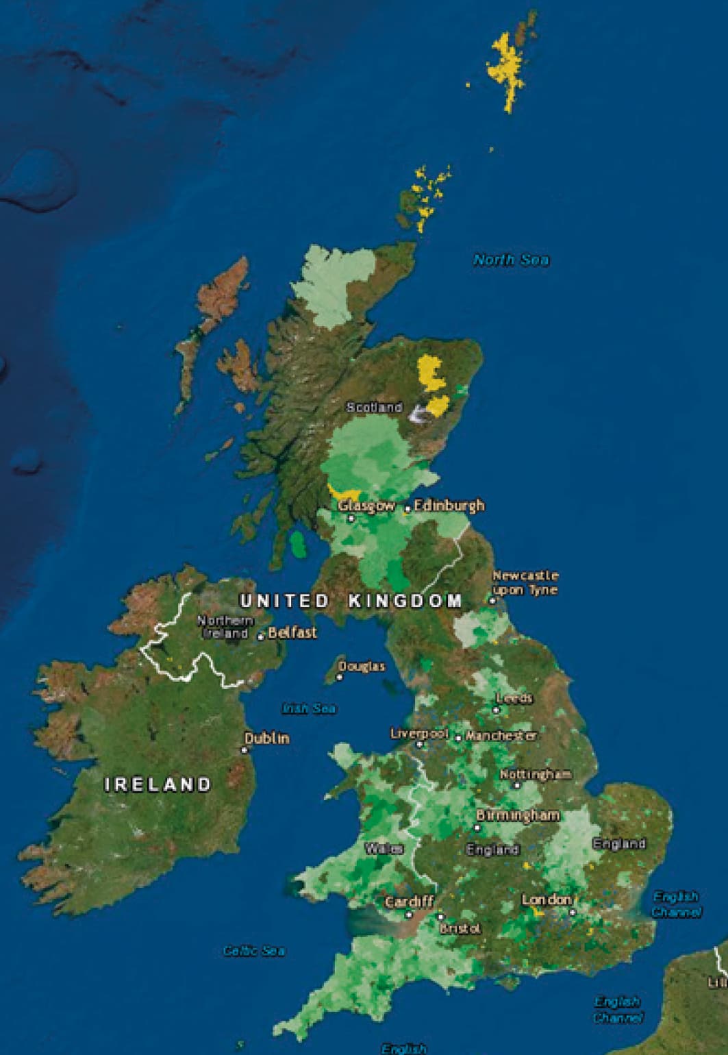
The UK Canopy Cover Webmap – areas in green have been completed.
Understanding our urban forests (the collective term for all the trees across a town or city) is critical for their effective management, and measuring canopy cover is often recognised as the first step in this process, followed by analysis of distribution, composition and structure. Many towns and cities across the UK have created canopy cover targets to enable increased tree planting efforts, improve the maintenance of urban forests and enhance the benefits trees provide to people and the environment.
In 2016, Forest Research undertook a study that assessed the canopy cover of 283 urban areas across England and seven cities in Scotland, to give a value at the town or city level (Doick et al. 2017). The study found an average canopy cover of just 16% and, consequently, promoted a canopy cover of 20% as an appropriate target to aim for (15% for coastal towns). Furthermore, it revealed that canopy cover values ranged from 3% to 45%. This range in the canopy cover across towns and cities demonstrated a need to understand how and why these values differ. To do so, canopy cover values need to be captured in more detailed analysis, at the within-town/city scale. Without such information, it is difficult to inform targeted planting strategies that seek to ensure long-term sustainable urban forest management.
The UK Canopy Cover Webmap was launched in December 2018 by Forest Research, with partners Trees for Cities and Brillianto, to enable the assessment of canopy cover for towns and cities across the UK at the electoral ward scale. It is hoped that this will develop a more detailed baseline understanding of the UK’s canopy cover. We’re actively seeking input to complete this map.
Citizen science
The citizen science project utilises i-Tree Canopy to undertake canopy cover assessments. This free and easy-to-use online tool generates random points and overlays them on aerial photography taken from Google Maps. For each point, the assessor selects whether the location is a tree, or not. This generates an estimate of canopy cover, along with an associated error of the estimate. For every assessment undertaken by project volunteers, the results are sent to Forest Research and uploaded on to the Canopy Cover webmap where they are publicly viewable and free to access/use. Initially the project aimed to only collect data on urban areas, but due to significant interest, rural wards are also available.
The project relies on the goodwill of volunteers to undertake canopy cover assessments. A large number of citizen scientists are engaged in the project, including those employed within the tree care industry, members of voluntary groups, such as the tree warden network, and other organisations, and interested members of the public. In total there have been over 200 individuals actively involved in completing assessments for the project, and this number continues to grow. Undergraduate and Master’s degree students are also taking advantage of the ability to collect new data online and analyse the land-use and land-cover drivers of urban canopy cover.
The project has provided opportunities for engagement with the sector for students when other voluntary roles may have been limited by the pandemic. The coronavirus pandemic has added a fresh dynamic to the project. During March 2020, the number of submissions to the webmap increased by over 118% compared to the previous month. The following months continued to see high levels of webmap submissions, and many citizen scientists who engaged with the project during lockdown 1.0 continue to send completed assessments in on a regular basis.
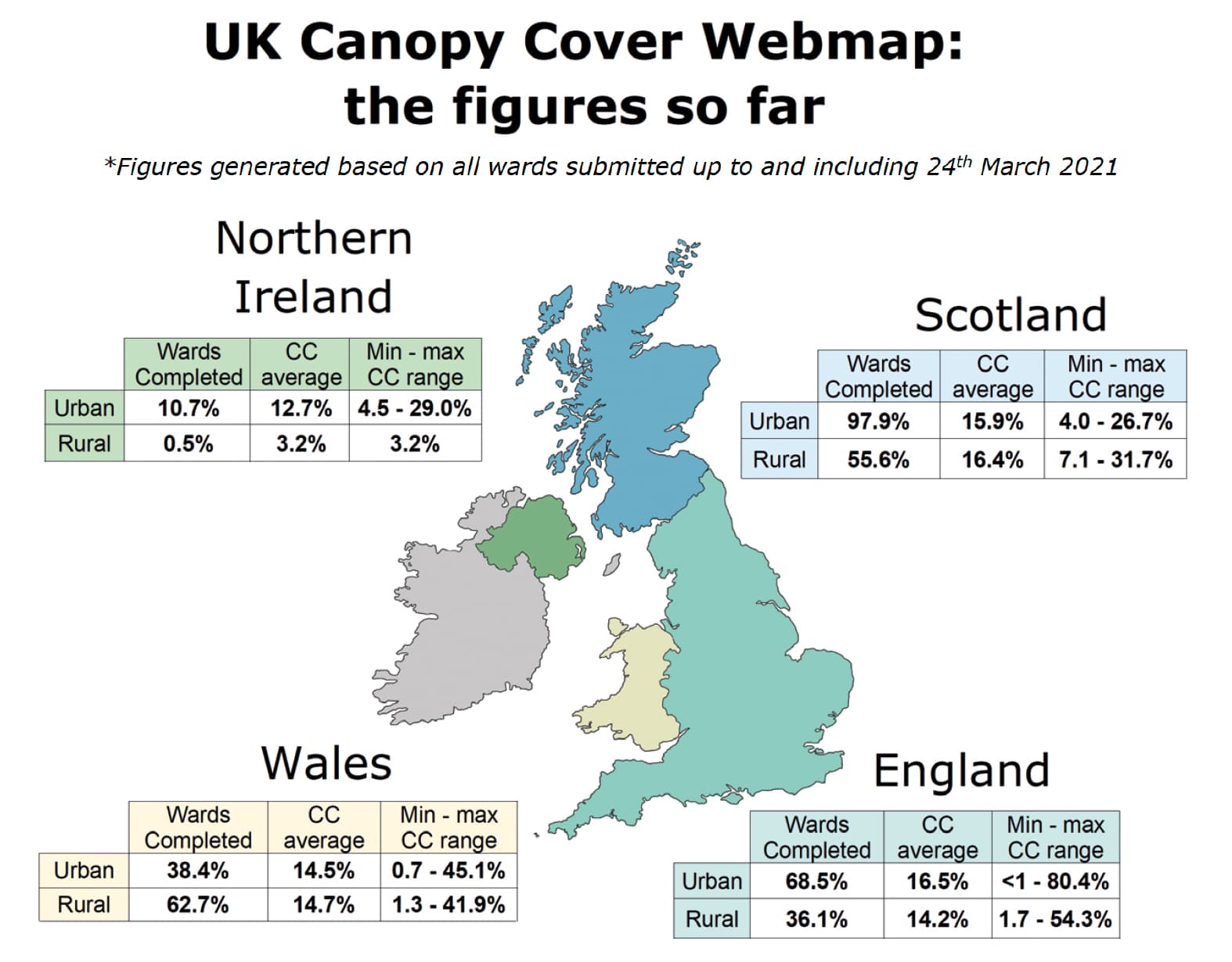
Average canopy cover, range and % completed for urban and rural wards per nation. (Kate Sparrow, Forest Research)
Datasets and trends
So far, over 63% of urban wards have been assessed across the UK and there is no doubt this number will have increased by the time this article is published. Estimates in cover for urban areas range from as little as <1% to over 80% (see below). This is a huge range in canopy cover and demonstrates just how much disparity there can be in our towns and cities, and the need to understand the driving factors for differences in canopy cover extent. The availability of a national dataset for canopy cover has already proved useful, particularly to local authorities, with canopy cover used to support strategic planning and to directly feed into policy.
It is important to recognise that canopy cover assessments are estimates and give a snapshot in time value. The project is about providing a national dataset as a baseline. It aims to give an indication of tree cover extent and distribution within urban areas, but also to use this initial data-gathering exercise to open up further opportunities for understanding the UK’s urban forests. The data may also offer a means of justifying further investment in urban forests. Not only can this information be directed towards increased planting efforts, but it can also be combined with other datasets such as land-use type, deprivation rates and population density to understand the possible driving factors for variation in canopy cover and inform targeted approaches to increasing and maintaining canopy cover.
There is also the potential to use historical satellite imagery available in Google Earth to identify changes in canopy cover over time. In a 2020 study by Doick et al., there was a predominant trend of increasing tree cover for 10 urban areas in Great Britain from the 1940s to 2018. However, over the past two decades there is more variation in whether tree canopy cover is increasing or decreasing in those areas. Such trend analysis can enable a degree of forecasting for urban forests, allowing realistic canopy cover targets to be set and to provide some context that allows us to understand some of the challenges that may have previously impacted urban canopy cover.
How to get involved
We would love to get this project completed this year, and strongly encourage anyone interested to have a go. There is a detailed instruction document available online which provides all the information you need to undertake an assessment. You can find this, and more information more information about the project, at: bit.ly/urbancanopycover. There is also a really handy video made by Paul Barton which gives an easy-to-follow tutorial on undertaking a canopy cover assessment for the project: bit.ly/canopycovervideo.
Assessments take on average 45 minutes to complete and results should be sent to canopycover@forestresearch.gov.uk. You can also use this email address to get in touch if you have questions about your assessment or would like to learn a bit more about the project.
To view the webmap and the results so far, please visit: bit.ly/canopy-cover-web-map.
References
Doick, K.J., Buckland, A., and Clarke T.-K. (2020). Historic urban tree canopy cover of Great Britain. Forests 11(10), 1049; www.mdpi.com/1999-4907/11/10/1049
Doick, K.J., Davies, H.J., Moss, J., Coventry, R., Handley, P., VazMonteiro, M., Rogers, K., and Simpkin, P. (2017). The Canopy Cover of England’s Towns and Cities (Research paper). Presented to Trees, People and the Built Environment 3 (TPBE3) Conference hosted by ICF: www.charteredforesters.org/Resource/doick-et-al-canopy-coverenglands-towns-cities-research-paper/
Kate Sparrow is an urban forest research scientist at Forest Research. Her research focuses on understanding the structure and composition of urban forests across the UK, and the extent of ecosystem services they deliver. She also manages the UK Canopy Cover Webmap project.
Dr Kieron Doick is Head of the Urban Forest Research Group (UFoRG) at Forest Research. UFoRG delivers scientific knowledge on UK urban forests: all the trees in and around the urban realm. Kieron’s research interests include urban forest resilience, urban tree valuation, and quantifying the role of urban forests in delivering ecosystem service benefits to society and valuing these services. @KieronDoickFR
This article was taken from Issue 193 Summer 2021 of the ARB Magazine, which is available to view free to members by simply logging in to the website and viewing your profile area.